




Details
ETM10M FOR ISRAEL – TERRAIN MESH
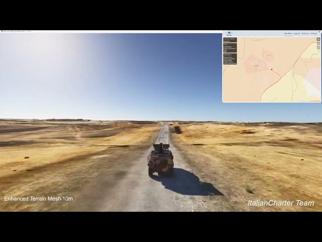
Enhanced Terrain Mesh 10m for Microsoft Flight Simulator 2024
Overview
This package delivers a high‑resolution 10‑meter terrain mesh for the entire territory of Israel, offering a dramatic improvement over the default MSFS2024 elevation data. Mountains, valleys, cliffs, wadis, and coastal formations gain accurate shape and depth, providing a far more immersive and realistic VFR experience.
Key Features
-
10‑meter (1/3 arc‑second) resolution mesh, based on Sentinel‑1 SAR data
-
Custom waterbody adaptation: lakes, shorelines, reservoirs, and coastal flats reshaped to match the new DEM
-
Helipad surfaces aligned to the 10‑meter grid
-
No LOD optimization required for this type of mesh
-
Zero performance impact thanks to efficient data processing
-
Optimized for VFR flying — best appreciated below 500 ft AGL
Technology & Data Sources
-
DEM/DTM: Sentinel‑1 SAR processed in SNAP13 for maximum accuracy
-
Mesh Technology: proprietary, developed in‑house
-
Hydrography adaptation: manual integration with MSFS2024 default water data
Why This Mesh
-
Significantly enhances the morphology of Israel’s terrain
-
Ideal for VFR, helicopter operations, bush flying, and training
-
Covers a region rarely improved by third‑party developers
-
Created by ItalianCharter Team – Gjanosh61, with over a decade of experience and thousands of downloads across the flight simulation community
Compatibility
-
Compatible with: MSFS 2024 only
-
Not compatible with MSFS 2020 (different SDK, different terrain system)
-
Works with all airport addons, photogrammetry, weather engines, and texture packs
Recommended Usage
For maximum visual fidelity, fly below 500 ft AGL, especially in mountainous and coastal regions.
Important Note for Best Terrain Quality
To achieve the highest possible fidelity of ETM10m in MSFS 2024, it is strongly recommended to enable the legacy option:
Old terraforming method
Options → Rendering → Ground Options → Old terraforming method
Although this setting may appear tedious or counter‑intuitive, it is necessary to ensure:
-
perfect compatibility with high‑resolution DEMs
-
correct elevation blending
-
elimination of micro‑artifacts introduced by the newest terrain rendering pipeline
-
stable and predictable morphology across all regions
MSFS 2024’s default terrain system occasionally applies aggressive smoothing and displacement blending that can slightly alter the intended shape of high‑resolution meshes. The Old terraforming method restores the expected behavior and guarantees that ETM10m displays exactly as designed, with full detail and no compatibility issues.
Тэги
ПРИМЕЧАНИЯ
Этот продукт оснащен нашей технологией simInstaller и доступен только после покупки через APP
Требования
Platform
Microsoft Flight Simulator 2024 – SU5 or later (Not compatible with MSFS2020 — different SDK and terrain system)
Recommended Hardware
These are not minimum requirements, but simply the configuration used during development and testing:
CPU: Intel Core i7‑10700K or equivalent
RAM: 24 GB
GPU: NVIDIA RTX series with 12 GB VRAM
Disk Space: 550 MB
The mesh works correctly even on lower‑end hardware. MSFS2024 is now significantly more stable and optimized compared to launch.
Post‑Installation Notes
After installation, open Dev Mode and enable:
Options → Rendering → Ground Options → Old Terraforming Method
This setting must be enabled each time you start MSFS2024. (This is currently required by MSFS2024 for custom terrain meshes.)
Recommended Settings for Best Quality
In Settings → General → Global Rendering Quality:
Terrain Level of Detail: 400
Displacement Mapping: Enabled
These settings provide the best visual fidelity for the 10‑meter mesh.
Support
For preliminary support, questions, or feedback, you can join the official ItalianCharter Team Discord:
https://discord.gg/DUmSTNxhkP
Рекомендации для вас

€ 13.90
$
USD 15.93
Все продажи указаны в евро. Другие валюты показаны только для справки.£
GBP 11.92
Все продажи указаны в евро. Другие валюты показаны только для справки.¥
CNY 106.76
Все продажи указаны в евро. Другие валюты показаны только для справки.
€ 15.99
$
USD 18.33
Все продажи указаны в евро. Другие валюты показаны только для справки.£
GBP 13.72
Все продажи указаны в евро. Другие валюты показаны только для справки.¥
CNY 122.81
Все продажи указаны в евро. Другие валюты показаны только для справки.
€ 14.99
$
USD 17.18
Все продажи указаны в евро. Другие валюты показаны только для справки.£
GBP 12.86
Все продажи указаны в евро. Другие валюты показаны только для справки.¥
CNY 115.13
Все продажи указаны в евро. Другие валюты показаны только для справки.
€ 19.90
$
USD 22.81
Все продажи указаны в евро. Другие валюты показаны только для справки.£
GBP 17.07
Все продажи указаны в евро. Другие валюты показаны только для справки.¥
CNY 152.84
Все продажи указаны в евро. Другие валюты показаны только для справки.
€ 12.99
$
USD 14.89
Все продажи указаны в евро. Другие валюты показаны только для справки.£
GBP 11.14
Все продажи указаны в евро. Другие валюты показаны только для справки.¥
CNY 99.77
Все продажи указаны в евро. Другие валюты показаны только для справки.
€ 14.99
$
USD 17.18
Все продажи указаны в евро. Другие валюты показаны только для справки.£
GBP 12.86
Все продажи указаны в евро. Другие валюты показаны только для справки.¥
CNY 115.13
Все продажи указаны в евро. Другие валюты показаны только для справки.
€ 12.90
$
USD 14.79
Все продажи указаны в евро. Другие валюты показаны только для справки.£
GBP 11.07
Все продажи указаны в евро. Другие валюты показаны только для справки.¥
CNY 99.08
Все продажи указаны в евро. Другие валюты показаны только для справки.
36.99
€ 35.14
$
USD 42.40
Все продажи указаны в евро. Другие валюты показаны только для справки.£
GBP 31.73
Все продажи указаны в евро. Другие валюты показаны только для справки.¥
CNY 284.09
Все продажи указаны в евро. Другие валюты показаны только для справки.
-5%
30-дневная минимальная цена:
€
36.99